Tuesday, June 19, 2012

Fresno Scraper Update

The Historical Committee has erected an information board relating to the Fresno Scraper that was used in the construction of Crystal Park roads in the early days of the Park.  It's located adjacent to the partially restored scraper at the Clubhouse.  The roofed sign mount was designed and constructed by the Historical Committee and the board itself was designed and made by Microcrafts Graphics and Displays, located at 3626 North Stone in Colorado Springs.  Microcrafts does excellent work and their prices are very reasonable.  More information on the Fresno Scraper is contained in an earlier post on this blog.

Friday, April 27, 2012

1880's Photos

Below are three photos of the entrance area to what is now the Upper Park, taken sometime in the 1880's, or perhaps as early as the late 1870's


(Courtesy of Southwest Museum of the American Indian Collection)

This is looking East through the gap with the toll booth in the center of the photo.  A number of other structures are visible.


This is looking South from a point West of the gap and above present-day Eagle Mountain Rd.  The lake would be in the lower left section of the photo and the cabin near where the present-day tennis court/playground is located.
This is a view down the old Crystal Park Trail, looking East from a point just below the gap.  The top of Sugarloaf Mountain is just visible in the left center.


Tuesday, April 3, 2012

More About Old Trees

Over the past few months, when the weather permitted, a number of Ponderosa Pines that appeared to fit the description of old trees were cored, using an increment borer.  This is a tool used by foresters to determine the approximate age of trees.  This process does little or no harm to the tree and has been an accepted method for many years.  Below are a few photos of some old trees and the stats that go with them.  It should be noted that the figures given are not exact and that the trees are cored at a height of about 4 feet from the ground, so they may in fact be as much as 10-20 years older than the estimate, depending on location, water availability, etc.

 This tree is located near the end of Sugarloaf Rd.  310 rings were counted and 10 added due to a small rotted core, giving it and estimated age of 320 years and an estimated pith date of 1692.


 These trees are located on the Lower Vista Rd. forestry trail.  The tree on the left, which has the well-healed fire scar shown in the first photo, had 311 rings counted.  10 were added to compensate for the core being slightly off center, giving the tree an estimated age of 321 years and a pith date of 1691.  The tree on the right is probably close in age, but although the tree appears perfectly healthy and sound, the core showed the tree is rotted internally starting about 3 inches into the tree, so an estimate was not possible.  It too has a fire scar.

This tree is also located on the Lower Vista forestry trail.  It has 311 counted rings, (no adjustment needed), giving it an age of 311 years and a pith date of 1701.  It also has at least one fire scar at the base, as well as exposed roots due to erosion.

This is a round from a beetle killed Ponderosa located along Crystal Park Rd. below the 3 Mile marker.  It shows that the tree was estimated to have an age of 299 years when it died (2011) and a pith date of 1712.  It also shows that the tree had a diameter of about 17 inches.  It was one of the larger trees.  Note the 14X loupe used to count the rings when needed.  Even with this magnification, counting can be difficult at times. Rings can be extremely close together so that they appear to be one ring, but they may show several years under high magnification (dry years?).


For much more information on old Ponderosa Pines on the Front Range, copy and paste this into your browser:

http://www.fs.fed.us/rm/pubs/rmrs_gtr110.pdf


Tuesday, March 20, 2012

Burro Trips to Crystal Park

Before there was a road to Crystal Park, many tourists chose to take a burro trip.  There were a number of  "burro lines" from which to choose.  They offered trips to Rainbow Falls, the Cave of the Winds, Williams Canyon, the Garden of the Gods, Crystal Park and a two day trip to the summit of Pikes Peak and back.  There were other burro trips available to tourists in other locations that would take them up Cheyenne Canyon and other points of interest.

This photo (courtesy of the Manitou Springs Heritage Center), is notated on the back, "Burro Party to Crystal Park", with the date July 12, 1906, and the names of all the participants.  These trips did not follow the route of the future auto road, but rather the "Pawnee Trail" from the top of Pawnee Ave.


Below are two pages from a Manitou tourist brochure with a highlighted section regarding the burro trip to Crystal Park from the Pioneer Livery Stable, at a cost of $1.50.

This photo below is of a group leaving for Pikes Peak on July 24, 1910.  It shows the "Burro Line" barn, located on Manitou Ave. (in what is now the 700 block, south side)The barn is gone now, but it's location was to the east of the little alley (visible in the photo) that's still there, now lined with small shops.


Below is a photo of a group leaving the Cliff House for trip  in the late 1800's, probably to the Garden of the Gods or Williams Canyon.  Note the older couple in a cart on the left.  Carts couldn't be used on the trip to Crystal Park, as there was only a narrow trail.

The Red Mountain Incline


Although not located in Crystal Park, the Red Mountain Incline was located close to it, as it ran to the summit of Red Mountain.  The remnants are easily visible from Crystal Park Rd., by looking north from Fire Cistern 215, about 3 1/2 miles from the gate.


The following article previously appeared in the Westside Pioneer:

 
The Other Incline
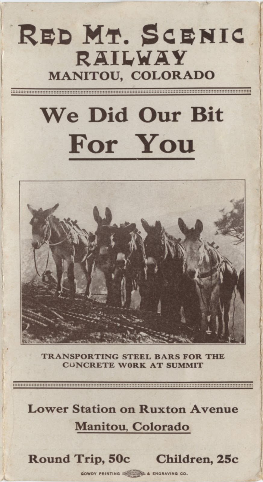
By Mel McFarland

       Some time ago I mentioned Manitou's other incline railway. Lets take a look at it today. Mt. Manitou sits west of downtown, with a grand view of out to Kansas. Red Mountain sits on the south side of Manitou, just below Crystal Park, with not as grand a view of the east, but a better view of Ute Pass and to the north.
       The Red Mountain Incline Company was formed in 1911 to build a cable railway to the top of Red Mountain. Richard Clough and Son, a local builder, was contracted to build the steep road. Clough came from a contractor family. His father and Uncles had a company that helped build the Colorado Midland Railway, Colorado Springs' reservoirs at Lake Moraine, and the Midland Terminal Railway so this kind of project was different, but not new. Work started in January, 1912. The road would have a station on Ruxton Avenue, about half way up near the Catholic Church. It would go straight to the top of Red Mountain, passing over the Colorado Midland Tunnel number one. A pavilion was planned for the top of the line. This led to the start of one of Manitou's most unusual traditions, but I'll talk about that later. Officers of the railway company were D. H. Rupp, R. D. Weir, T. J. Sandford and James A. Sevitz.
       The work took about eight months and it opened in the late summer. There was a long steep bridge as part of the line and a big electric sign was mounted on its side, proclaiming the name of the railroad. It was the first truly big electric advertisement in the area. But the Red Mountain Incline proved to be too scary for most. The bridgework was the truly frightening part. The structure made the trip more interesting since it was way above the ground. Many refused to ride down on the cars and walked the steep trail down from the pavilion. Within a few years the Incline was closed. The line was offered to the Midland for scrap, but they decided it wasn't worth the effort. The structure was eventually torn down, but I hear there are still bits of iron along its route. You can plainly see the foundation for the mechanical plant that was at the top of Red Mountain. Previously, the summit had been where Emma Crawford was buried, and as a result the Incline builders found a new gravesite for her. It was not as secure, and it eventually washed down the mountain! This was the event that inspired Manitou's modern-day coffin races!

Below are scans of Red Mountain Incline brochures (courtesy of the Manitou Springs Heritage Center).  Click to enlarge.